
Things to Do: Day Hikes From Queenstown

Queenstown is known for its adrenaline-filled activities, but being surrounded by mountains, lakes, forests, and valleys also makes it a great place for exploring on foot. Whether you've got an hour to spare or want to spend the whole day on the trail, there are plenty of options within easy reach of town.
This guide rounds up eight of our favourite day walks from Queenstown, covering a mix of easy walks and more challenging full-day hikes.
Key Takeaways
Queenstown has walks for every level, from flat 40-minute strolls to full-day alpine hikes.
The closest walks (Queenstown Gardens and Queenstown Hill) start right in central Queenstown, no vehicle needed.
Slightly further out, walks in Kelvin Heights, Arrowtown, and Glenorchy are all within a 45-minute drive.
Longer day hikes include the Ben Lomond Track and various options on the Routeburn Track.
All the walks in this guide are free to access, though some require driving to the trailhead.
Queenstown Gardens Trail

The Queenstown Gardens sit on a small peninsula on the shore of Lake Wakatipu, right next to central Queenstown. The trail is a relaxed loop that takes you along the lakeshore, through mature trees, and past the rose garden, all with great views across the lake.
There's also a frisbee golf course, a children's playground on the Marine Parade side, and a skate park by Park Street, so it's a good option if you're travelling with kids.
Distance: 2 km loop
Duration: Around 40 minutes
Difficulty: Easy
Start/finish: Queenstown lakefront on Marine Parade
Getting there: Walking distance from central Queenstown
Queenstown Hill Time Walk

Queenstown Hill, known by Māori as Te Tapunui, or "the mountain of intense sacredness," is a local favourite for the panoramic views from the summit.
The track climbs around 500 metres from the trailhead to the top, passing a small mountain pond and the Basket of Dreams sculpture along the way.
From the summit, you get 360-degree views of The Remarkables, Cecil Peak, Frankton Arm, and Queenstown Bay. It's a solid uphill climb, but it's worth it on a clear day.
Distance: 5.4 km return
Duration: 2-3 hours
Difficulty: Moderate (steady uphill)
Start/finish: Belfast Terrace, Queenstown
Getting there: Walking distance from central Queenstown. Drive time from central Queenstown is around 5 minutes if you'd rather drive to the trailhead
Kelvin Heights Peninsula Trail

Kelvin Heights Peninsula is on the opposite side of the lake from central Queenstown. The trail follows the edge of the peninsula, taking you past the Queenstown Golf Club and providing great views back across the lake to Queenstown and The Remarkables.
For a shorter walk, start from the Kelvin Heights carpark and loop around the peninsula itself. For a longer one, drive to the Kawarau Falls Bridge first, then cross over the historic bridge, and follow the lakeside trail around the peninsula and back.
Distance: 3.5 km for the peninsula loop, or 10.5km return for the longer route
Duration: Around 1 hour for the peninsula loop, or around 5 hours return from the Kawarau Falls Bridge
Difficulty: Easy
Start/finish: Kelvin Heights carpark (peninsula loop), or the Kawarau Falls Bridge (longer route)
Getting there: Around a 10 -15 minute drive from central Queenstown to the Kelvin Heights carpark, or around a 5-10 minute drive to the Kawarau Falls Bridge.
Lower Wye Creek Track

The Lower Wye Creek Track is a steep, off-the-beaten-track option in the Remarkables Conservation Area. From the carpark near Wye Creek Bridge, the track climbs the pipeline from the hydro dam via a steep zigzag, then continues through beech forest into the Lower Wye Creek basin.
This is a more advanced walk and is best suited to summer, when there is no longer snow on the higher sections.
Tip: Take care at the entry and exit points of the carpark, as the carpark is just off a busy highway.
Distance: Around 4 hours return to Lower Wye Creek basin
Difficulty: Advanced (steep, uneven terrain)
Start/finish: Wye Creek carpark, off State Highway 6
Getting there: Around 20 minutes drive south of Queenstown
Arrowtown Millennium Walk

The Arrowtown Millennium Walk is a wide, tree-lined loop track that runs along the banks of the Arrow River. It was built in 1998 to commemorate 150 years of European settlement in Otago, and it's a relaxed walk that suits most fitness levels.
Part of this trail was the location for the Gladden Fields in The Lord of the Rings, so it's a nice link for fans of the films. The track also connects to Tobins Track, which you can branch off onto for a longer, hillier walk with views over the Arrow Basin.
Distance: 4 km loop
Duration: Around 1 hour for the loop
Difficulty: Easy
Start/finish: Butler Green carpark off Ramshaw Lane or Ford Street, Arrowtown
Getting there: Around 20 minutes drive from central Queenstown
Glenorchy Lagoon Walkway

Glenorchy is located at the head of Lake Wakatipu, about 45 minutes drive from Queenstown.
The Glenorchy Lagoon Walkway takes you through the wetlands just north of the township, with boardwalks over the water and views out toward Mount Earnslaw (Pikirakatahi) and Mount Alfred (Ari).
On calm days in spring and late autumn, the snow-capped mountains reflect in the lagoon, making for some great photography.
The wetlands are also full of native birdlife, with sightings of pied stilts, black swans, oystercatchers, New Zealand shovellers, grey teal, scaup, and occasionally New Zealand falcons and swamp harriers.
Distance: 3.2 km
Duration: 1-2 hours
Difficulty: Easy
Start/finish: Waterfront carpark at the northern end of Glenorchy
Getting there: Around 45 minutes drive from Queenstown
Longer Day Hikes
Ben Lomond Day Hike

Ben Lomond is the mountain that towers directly above Queenstown. On a clear day, the summit provides panoramic views over Queenstown, Lake Wakatipu, and the surrounding ranges, including Cecil Peak, Walter Peak, and The Remarkables.
There are several ways to do it, depending on your fitness and duration preference.
Tiki Trail To Ben Lomond Summit (Full Hike)
The most demanding option, with a 1,438-metre elevation gain from Queenstown and a distance of 14 km return, taking 6-8 hours. The final section from the saddle to the summit crosses private land and is steeper and rougher, and you'll need alpine equipment if attempting it in winter.
Tiki Trail To Ben Lomond Saddle (Mid-Length)
A shorter option that takes you to the 1,326-metre saddle and back. Around 10 km return and 5 hours, this gives you a real taste of the mountain without committing to the summit.
Skyline Gondola Top To Ben Lomond Saddle (Shortest)
Ride the Skyline Gondola up to the top, then hike from there to the saddle and back. Around 7 km return and 3-4 hours, this is a good option if you want the views without the full climb.
Start/finish: Skyline Gondola base at the top of Brecon Street, or Skyline complex if taking the gondola
Getting there: Walking distance from central Queenstown
Difficulty: Advanced (summit); moderate (saddle from gondola)
Routeburn Track Day Walks
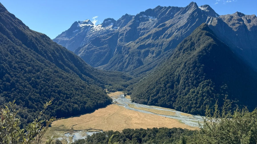
The Routeburn Track is one of New Zealand's Great Walks, and although it's a multi-day track, several excellent day walks can be done from the Glenorchy end without needing to book huts or campsites.
The Routeburn Shelter (the eastern trailhead) is around a 1-hour drive from Queenstown via Glenorchy.
There are three main day walk options from this end of the track.
Bridal Veil Falls
The easiest option, running about half to three-quarters of the way to the Routeburn Flats Hut before turning around. The trail is wide and mostly flat, with beautiful views of the Dart River and the falls themselves. Around 8-10 km return and 3-4 hours.
Routeburn Flats Hut
A step up in commitment, with a gradual 300-metre climb along the way. You'll see Bridal Veil Falls, the Dart River, and the valley views, and the Flats Hut itself is in an open grassy area with sweeping views. Around 15 km return and 4-5 hours.
Routeburn Falls Hut
The longest of the three options. From the Flats Hut, the track climbs steadily through beech forest and up the valley to the Falls Hut, which is near the bushline with views of the impressive Routeburn Falls. Around 19.6 km return, 6-7 hours, and moderate to hard difficulty.
Start/finish: Routeburn Shelter, at the Glenorchy end of the Routeburn Track
Getting there: Around 1 hour drive from Queenstown via Glenorchy
Season: The Great Walks season runs from 1 November to 30 April. Outside this window, the track is still open, but hazardous conditions and avalanche risk mean off-season hikes are only recommended for experienced hikers.
Whether you're after an easy walk close to town or a full-day hike into the mountains, Queenstown has no shortage of day walk options. With so many great tracks within easy reach, it's well worth setting aside a day to experience a different side of Queenstown beyond its usual adrenaline-filled attractions.
Frequently Asked Questions
Do I need hiking boots for walks around Queenstown?
No, not for all of them. Many of Queenstown's shorter walks, such as the Queenstown Gardens Trail and Arrowtown Millennium Walk, can comfortably be done in sturdy sneakers. For longer or steeper hikes like Ben Lomond or Lower Wye Creek, hiking boots with good grip are recommended, particularly if the track is wet or uneven.
Can I do hikes around Queenstown in winter?
Yes, but conditions vary depending on the walk. Lower elevation tracks, such as the Queenstown Gardens Trail and Arrowtown Millennium Walk, are accessible year-round. Higher alpine walks like Ben Lomond can have snow, ice, and avalanche risk during winter, and may require alpine equipment and experience. Always check the latest track conditions before setting out.
Are Queenstown hikes free?
Most day walks around Queenstown are free to access. You may need to pay for transport to some trailheads, and certain options, such as starting the Ben Lomond Track from the Skyline Gondola, have a cost if you choose to use the gondola.


